|
Michigan Department of Natural Resources Jackson County (T4S, R3W, Section 36) Hillsdale County (T5S, R3W, Sections 1,2,9,10,11) Surveyed July 23 and 24, 1991 Michael P. Herman Environment The South Branch of the Kalamazoo River is one of many large tributaries
that empty into the main stream of the Kalamazoo River. The name "Kalamazoo"
is Indian in origin and is from the Indian word Kikalamazoo, which means
mirage or reflecting river. The South Branch is classified as a second-
quality trout feeder stream. It is one of only five designated trout streams
in the Jackson Fisheries District. The South Branch of the Kalamazoo River originates just north of the
city of North Adams in central Hillsdale County and flows in a northwesterly
direction until it empties into the Kalamazoo River mainstream in the
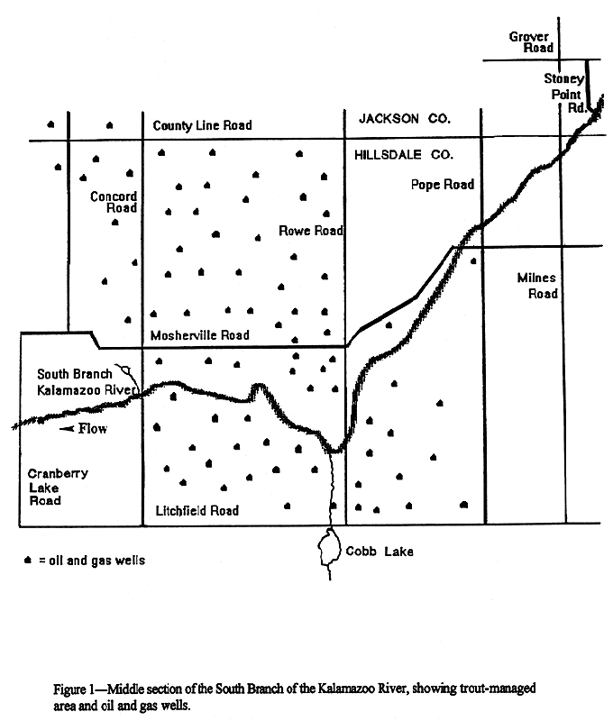
city of Albion. The map in Figure 1
shows the middle portion of the South Branch. There are several lakes
that have a direct connection to the South Branch including Willits Lake,
Cobb Lake, Hastings Lake, Gray Lake, Mill Lake, Mud Lake, Brail Lake,
Bartelle Lake, Swains Lake, Gregory Lake and several small unnamed ponds.
Although most of these lakes are small, they are significant because of
their warmwater fisheries influence on the South Branch. Among the tributaries
to the South Branch are Beaver Creek, Conger Drain, Swains Lake Drain,
and an unnamed drain just south of the city of Homer. The South Branch is approximately 43 miles long from its origin to its
confluence with the Kalamazoo River mainstream. The total fall of the
South Branch is approximately 200 feet. Much of the South Branch flows through gently rolling farmland and small
wood lots. The predominant land use in this watershed is agriculture and
much of the surrounding area is rural. The soils contiguous to this river
are mainly very poorly drained muck and sandy loams. The South Branch
ranges from 2 to 75 feet wide with an average width of 25 feet and an
average depth of approximately 2 feet. Discharge, as measured in cubic
feet per second is estimated at 7 cfs in the upper portion of the river
and at 81 cfs in the lower section. The section of the South Branch of the Kalamazoo River that has historically
been managed for brown trout is approximately 7 miles long. The best trout
habitat exists just upstream from Figure
1, from the bridge at Stoney Point Road (T4S, R2W, S31) in southern
Jackson County to the Mosherville Road bridge in Hillsdale County (T5S,
R3W, S5). A good variety of high-quality trout habitat exists in that
section of the river. Deep pools, shallow pools, runs, and riffles with
rubble and gravel are all present which provide a diversity of habitat
types for brown trout feeding, resting, and spawning. There is a continual
flow of water in the South Branch throughout the year. The banks are moderately
stable and are bordered predominantly with overhanging brush and shrub
vegetation. Although there is a considerable amount of favorable trout habitat in
the managed section of the South Branch, significant amounts of sand severely
limit production in this stream. Sand covers from 30-90 % of the stream
bottom in the area managed for trout; this negatively impacts the fish
community. Virtually all of the land that borders the South Branch is privately
owned and no state land presently exists. There are approximately 4 miles
of abandoned railroad grade which anglers routinely use to access this
river. Nearly all of the bridge crossings within the trout-managed area
are posted with "no trespassing" signs, however, many property owners
allow anglers to access the stream via their property. Except for the parts of the South Branch that lie within the city limits
of Homer and Albion in Calhoun County, development in the watershed is
limited to only a few residential homes and small businesses. The section of the South Branch between the cities of Homer and Albion
is popular with canoeists. The launch point is located on the southeast
corner of the river and M&endash;60 in Homer. Some canoeing also occurs
upstream from Homer. A notable bedrock formation is located about 300
yards south of the F&endash;Drive South bridge in Calhoun County. The
rock exposure belongs to a geological formation known as the Marshall
Sandstone and is the principal aquifer for the City of Albion. The South Branch of the Kalamazoo River has been popular with mainly
local anglers since the early 1950's when trout management through stocking
began. It was stocked with legal-size rainbow trout from 1950 through
1954 and with brown trout yearlings from 1973 through 1993. This river
has never been chemically rehabilitated. The earliest survey on file was an electrofishing survey upstream from
Hanover Road in Jackson County in 1952. No trout were captured. Species
caught included northern pike, smallmouth bass, rock bass, grass pickerel,
white sucker, hog sucker, redhorse sucker, lake chubsucker, bullhead,
and stonecat, as well as several varieties of chubs and minnows. Many
of these species reflect the influence that contiguous lakes have upon
the South Branch in this section of the watershed. A backpack shocker survey in November of 1973 below the Mosherville Road
(west) site resulted in the capture of 14 brown trout ranging in size
from 6 to 16 inches. Many other trout were observed but not captured during
this survey. Numerous spawning redds were also noted. Four sites were surveyed by electrofishing in October of 1980. The sites
were upstream from Pope Road, Rowe Road, Cranberry Lake Road, and Mosherville
Road (west). A 240-volt DC stream shocker unit with two probes and a four
ampere output was used. Fifty&endash;two brown trout, including several
wild young&endash;of&endash;the&endash;year, were caught during this survey.
Also captured were white suckers, hog suckers, central mud minnows, mottled
sculpins, and several different species of forage minnows. Numerous spawning
redds were observed at the Pope Road site during this survey. Several brown trout ranging in size from 2&endash;11 inches were caught
during a July 1985 survey of the Concord Road and Mosherville Road sites.
In July of 1986, brown trout ranging in size from 6-19 inches were found
to be abundant upstream from the Rowe Road crossing of the South Branch.
Drought conditions during the spring and summer of 1988 resulted in very
few trout captured during a July survey of the Concord Road and Mosherville
Road sites. In July of 1991, the Grover Road, Pope Road, and Rowe Road sites of the
South Branch were surveyed with a 240&endash;Volt DC stream electrofishing
unit. The fish community was found to be similar to past surveys of these
sites (Table 1). White suckers, creek chubs, and grass pickerel were common
but were not considered overabundant. The only growth rate information was from a stream electrofishing survey
of the Pope Road and Rowe Road sites in March and October of 1993. Although
brown trout growth was slightly below average, it is not considered poor.
The fish sampled during this survey appeared healthy and in good condition. A tagging study was conducted on the South Branch of the Kalamazoo River
in 1991 in an effort to estimate angler harvest of stocked brown trout.
Approximately 2300 (63 %) of the brown trout stocked into the South Branch
in 1991 were marked with 1.25 inch Floy tags. Anglers returned only 38
tags between June and September 1991, representing a harvest rate of only
1.6 %. Tag loss was suspected to be high and may have occurred due to
several reasons. Factors that could have contributed to the observed low
number of tag returns include the following: 1) Tag loss (or shedding) after stocking; 2) High hooking mortality of sub&endash;legal tagged fish; 3) Mortality due to tagging; 4) Natural mortality of tagged trout before reaching legal size; 5) Tags not returned by anglers. Tag loss may have been a major problem throughout this study. None of
the trout lost their tags at the hatchery and none were lost at the access
sites immediately after planting. However, 41% of brown trout stocked
in a small spring&endash;fed pond shed their Floy tags over a 3&endash;month
period during the summer of 1990 (Dexter 1990). The brown trout used in
that pond experiment were similar in size to those used in the South Branch
study, and the tags used were identical, except for color. The trout tagged for the South Branch study averaged only 6.4 inches
in total length, and their small size may have been a major reason for
the suspected high tag losses. Several tag studies using larger fish and
Floy tags similar to those used in the study on the South Branch have
experienced higher tag retention rates (Ebner and Copes 1982; Franzin
and McFarlane 1987). Angler returns of Floy tags from brown trout tagged at a small size did
not yield good estimates of angler harvest. Since tag loss was probably
significant, harvest estimates were undoubtedly underestimated. However,
I suspect the estimates would only be slightly higher because many of
the small brown trout stocked probably do not survive to legal size. Future
studies should emphasize quality control and uniformity in tagging technique
to assure maximum tag retention. Additionally, it is also recommended
that only fish over 8&endash;inches in total length be used for Floy tag
harvest estimate experiments. More information regarding this study can
be found in the Technical Report entitled "Use of Floy Tags to Determine
Angler Harvest of Brown Trout in Two Southern Michigan Streams", Fisheries
Technical Report No. 94-5. Because of the apparently low angler harvest and the low number of tagged
trout recovered during electrofishing surveys conducted in July of 1991,
survival of stocked trout became suspect. On March 24, 1993, all of the
hatchery yearling brown trout stocked into the South Branch of the Kalamazoo
River were fin&endash;clipped. The objective of that study was to estimate
the percent contribution these fish made to the existing fishery by monitoring
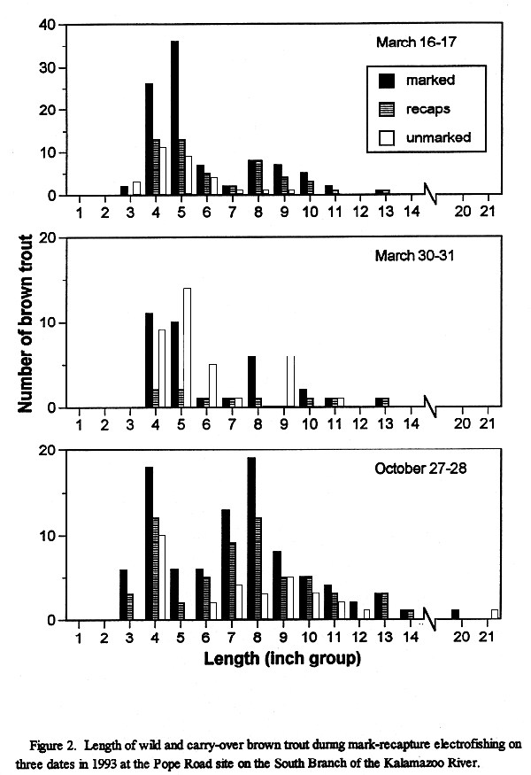
their survival and abundance. One week prior to stocking, on March 16 and 17, the Pope Road and Rowe
Road sites, were electrofished with a stream shocker. A total of 126 browns
were captured. The population estimates were 536 brown trout per acre
at the Pope Road site and 126 brown trout per acre at the Rowe Road site.
Yearling brown trout, all resulting from natural reproduction of this
wild fish stock, accounted for nearly 40% of the fish that were aged using
fish scales. The other 60% were older fish of either wild or hatchery
(carryover) origin. Population estimates for each site are in Table 2,
and brown trout size structures are shown in Figure
2. A post-stocking survey was conducted at the Pope Road study site on March
30 and 31,6-7 days after stocking. Only that site was sampled because
of high water conditions. A total of 69 trout were captured during this
survey, of which only 10 were recently stocked hatchery trout. The population
of wild and carryover trout at this site was estimated at 436 trout per
acre. The majority of the hatchery fish had either migrated from the stream
sections where they had been stocked or had perished. The Pope Road study site was electrofished again on October 27-28. Captured
were 115 unclipped brown trout and only 9 clipped trout. Mark-and-recapture
estimates, per acre, were 466 wild and carryover origin and 34 survivors
from the 1991 planting. Population estimate data are summarized in Table
2 and size structure of wild and carryover brown trout captured during
these surveys is illustrated in Figure 2. Because of the apparent failure of the stocked brown trout to make a
significant contribution to the existing fishery, annual plants were discontinued
in 1994. This fishery will be monitored regularly to determine the status
of brown trout reproduction, growth, and survival. Informal angler surveys were conducted on opening day of trout season
in 1991, 1992, and 1993. Whenever face&endash;to&endash;face interviews
were not possible, trout survey forms were attached to the windshields
of vehicles parked at bridge crossings of the South Branch. These surveys
asked questions regarding frequency of angling, if catch&endash;and&endash;release
was practiced, trip length, and number of trout caught. Also asked were
questions regarding the existing trout stocking programs, trout regulations,
and angler suggestions for improving the existing fisheries. Although
several interviewed anglers had caught some legal-size trout on the day
they fished, many anglers also reported catching and releasing many sub&endash;legal
trout. The overall response from anglers participating in these face&endash;to&endash;face
and mail survey interviews was very positive. A biological survey was performed by the Surface Water Quality Division
of the D.N.R. on the South Branch of the Kalamazoo River at the Pope Road
site in July of 1990 to evaluate overall stream quality. An electrofishing
survey of a 200&endash;foot section of river upstream from Pope Road resulted
in the capture of 22 brown trout. Other species captured included grass
pickerel, creek chub, white sucker, mottled sculpin, green sunfish, pumpkinseed,
and largemouth bass. Benthic macroinvertebrates were also sampled and
a total of 22 different varieties were collected. The most abundant invertebrates
were amphipods, which resemble tiny shrimp&endash;like animals and are
an important food source for trout. The diversity of benthic organisms
at this site is considered very good. During a routine stream shocking survey in July of 1988, odoriferous
petroleum&endash;type residues were observed when the sediments were disturbed
in an area immediately upstream from the Concord Road bridge site. Many
Marathon Oil wells are in the general area and a Marathon Oil Company
storage facility is located approximately one&endash;half mile upstream
from the Concord Road site (Figure 1).
A search of the DNR Surface Water Quality Division records resulted in
the following. In June of 1990, an employee of the Marathon Oil Company
reported a gas line leak at a well in Section 36 of Scipio Township. This
site is approximately 4 miles south of the South Branch of the Kalamazoo
River and because of the minor nature of the leak, likely had no negative
impact on the river. In August of 1990, a report was filed by the Surface
Water Quality Division regarding a small spill of brine and oil at a well
located in Section 14 of Scipio Township. This site is approximately one&endash;half
mile south of the South Branch of the Kalamazoo River. The filed report
indicates that this spill was minor and was entirely contained inside
the working area dike of the well. In August of 1957, the Aurora Gasoline Company and the McClure Oil Company
were issued a permit by the Department of Conservation to drill an oil
well in Section 10 of Scipio Township. This site is approximately one&endash;half
mile east of the Concord Road bridge crossing of the South Branch of the
Kalamazoo River (Figure 1). A "blow&endash;out" of this well occurred which lasted a total of 25
hours. No estimate of how many gallons of gas and oil discharged from
the well was recorded. Cleanup of the area was accomplished by pumping
oil out of the river at the Concord Road bridge using suction pumps and
by removal of oil and contaminated soil in the immediate area of the well.
Clean sand was hauled in to fill the void around the oil rig created by
removal of contaminated soils. Although control of the well was achieved
after 25 hours of flowing wild, bubbling gas around the drilling rig and
the adjacent swamp was reported to continue for some time. The current management of the South Branch of the Kalamazoo River as
a second-quality, cold-water designated trout stream should continue.
Past surveys have indicated the ability of this stream to support large
trout and the survival of trout through the winter has historically been
good. Although there is limited natural reproduction in this river, it
is probable that survival of naturally reproduced brown trout will increase
subsequent to the discontinuation of stocking in 1994. Alternate year
surveys conducted in early spring will enable us to monitor natural reproduction,
growth, survival, and year&endash;class strength of brown trout in the
South Branch. The main goal of management of this river will be to create a larger population of brown trout than presently exists. A major obstacle to attainment of this goal is the large amount of sand in the river which severely limits aquatic invertebrate and fish production. A proposal to remove sand from the prime river sections of the South Branch of the Kalamazoo River is discussed in the Management Plan section of this document. A second management goal is to maintain the existing excellent water
quality in the trout-managed section of the South Branch. The large number
of gas and oil wells in the immediate vicinity of this river will require
continued coordination with Surface Water Quality Division personnel.
Judicious water quality monitoring efforts in this environmentally sensitive
area will ensure the continued protection of this vital resource. Report completed: March, 1994. Dexter, J. L. 1002. Anger catch and densities of stocked and wild brown
trout (Salmo trutta) in Augusta Creek, Michigan. Michigan Department
of Natural Resources, Fisheries Technical Report 91-9, Ann Arbor. Ebner, M. P. and F. A. Copes. 1982 Loss of Floy anchor tags from lake
whitefish. North American Journal of Fisheries Management 2:90-93. Franzin, W. G. and G. A. McFarlane. 1987. Comparison of Floy anchor tags
for tagging white suckers. North American Journal of Fisheries Management
7:307-309. Herman, M. P. 1994. Use of floy tags to determine angler harvest of brown
trout (Salmo trutta) in two southern Michigan streams. Michigan
Department of Natural Resources, Fisheries Technical Report No. 94-5,
Ann Arbor. Table 1.-Species, relative abundance, and length of fish collected
by stream electrofishing at three sites on the South Branch of the Kalamazoo
River, July 23 and 24, 1991.
Table 2.&endash; Mark-recapture population estimates of brown trout from
the south branch of the Kalamazoo River during 1993.
Jackson County (T4S, R3W, Section 36) Hillsdale County (T5S, R3W, Sections 1,2,9,10,11) MANAGEMENT PLAN Michael P. Herman Recent survey information collected on the South Branch of the Kalamazoo
River indicated very low survival of stocked hatchery trout. Additionally,
although survival of stocked trout is poor, the stocked fish have likely
impacted the wild brown trout through direct competition for food and
space and may have depressed the naturally reproduced brown trout population
by predation. A primary goal of the Fisheries Division of the Department
of Natural Resources is to promote the increase of wild trout where possible
while maintaining or improving the existing fishery. Beginning in the
spring of 1994, brown trout stocking will be discontinued. Alternate year
electrofishing surveys beginning in 1995 will allow us to monitor natural
reproduction, growth, survival, and year&endash;class strength of the
wild brown trout population. The main goal of management of the South Branch of the Kalamazoo River
is to create a larger population of brown trout than presently exists.
A major obstacle to attainment of this goal is the large amount of sand
which presently exists in the river and which severely limits aquatic
invertebrate and fish production. The main source of sand is from farm fields which border the South Branch
of the Kalamazoo River. Runoff from gravel road crossings of the river
also contribute smaller amounts of sand. Inspection of the upper reaches
the this river are planned to identify specific areas with significant
erosion potential. Subsequent to this inspection, landowners will be contacted
and plans for reducing erosion will be suggested. Natural buffer strips
which effectively filter sediment, organic matter, and other pollutants
from surface water runoff will be recommended. Direct benefits from buffer
strips include: 1) collection of coarse grained sediment, thereby reducing
off&endash;site sedimentation; 2) reduction of phosphorous, nitrogen,
and organic matter loading; and 3) slowing the movement of water, thereby
reducing water velocities and allow some percolation into the ground.
Additionally, buffer strips can provide valuable wildlife habitat. Results of investigations at Hunt Creek and Poplar Creek by Gaylord Alexander
and associates (1982) indicate that sand has major negative impacts on
trout populations. After sand was removed from Poplar Creek, trout production
increased by over 40 percent. These investigations also illustrated how
sand settling basins were able to reduce sand bedload sediments by as
much as 86 percent. A proposal to construct a sediment trap immediately above the Pope Road
bridge crossing of South Branch of the Kalamazoo River was proposed in
1983 but was not accomplished. This proposal still has merit and should
be attempted. The proposed site is on private property and will require
an easement. Size of the sediment basin size will be modeled after the basin constructed
on Poplar Creek. Since average depth at this location is approximately
2 feet, the recommended basin depth is 4 feet. Recommended width is 25
feet (stream width) and recommended length is 160 feet. This will result
in a storage capacity of approximately 300 cubic yards. If this basin
is constructed, it will require periodic excavation if it is to continue
to be effective. The installation of natural buffer strips along the river, together with
the removal of excess sand, will result in an increase of habitat that
is suitable for the growth and survival of brown trout. This action will
also result in the restoration of gravel spawning areas, thereby improving
conditions for natural reproduction. If the proposed sediment basin proves
successful, placement of additional basins will be considered. Alexander, Gaylord R. and Edward A. Hansen. 1982. Sand Sediments in a
Michigan Trout Stream Part II. Effects of Reducing Sand Bedload on a Trout
Population. Michigan Department of Natural Resources, Fisheries Research
Report No. 1902, Ann Arbor, MI. Hansen, Edward A., Gaylord R. Alexander and William H. Dunn. 1982. Sand
Sediments in a Michigan Trout Stream Part I. In&endash;Stream Sediment
Basins: A Technique for Removing Sand Bedload from Streams. Michigan Department
of Natural Resources Fisheries, Research Report No. 1901, Ann Arbor, MI. Peterson, Amy, Ralph Reznick, Sally Hedin, Martin Hendges and Dennis
Dunlap. 1992. Guidebook of Best Management Practices for Michigan Watersheds.
Michigan Department of Natural Resources, Surface Water Quality Division,
Lansing, MI. Plan completed: March, 1994.
Last Update: 08/05/02
[email protected] |
|||||||||||||||||||||||||||||||||||||||||||||||||||||||||||||||||||||||||||||||||||||||||||||||||||||||||||||||||||||||||||||||||||||||||||||||||||||||